Kurse
- Trainer/in: Andreas Brück
- Trainer/in: Nikita Konwar Gogoi
- Trainer/in: Gesa Henning
- Trainer/in: Nija-Maria Linke
- Trainer/in: Georg Müller
- Trainer/in: Felipe Andres Vergara Ovando
- Trainer/in: Andreas Brück
- Trainer/in: Juan Manuel Gavieiro
- Trainer/in: Georg Müller
Mittels einer Einführung in theoretische und methodische Grundlagen werden analoge und EDV-gestützte Analysen von Raum sowie sonstige Werkzeuge und Methoden der Raumanalyse und Kommunikation von Forschungsergebnissen mit Anwendungsbezug in der Stadt- & Regionalplanung und -forschung integriert vermittelt und praktisch erprobt. Zudem werden Analyse, Darstellung und Präsentations- und Kommunikationsprozesse mithilfe praktischer Beispiele analysiert. Zu den grundlegenden Inhalten gehören u.a.: * Methoden & Werkzeuge der Raumanalyse (inkl. Grundaufbau von GIS, Datenarten, -gewinnung und -filterung) * Analysemethoden, Datenmodellierung und -strukturierung, geowissenschaftlicher Daten, (inkl. GIS-gestützter Visualisierung und Kommunikation) sowie Zusammenwirken verschiedener EDV-Systeme (GIS, CAD, Datenbanken, 3D, usw.) * Ausblick auf weiterführende LV und zukünftige Entwicklungen und Konzepte (z.B. Virtuelle Realität, Künstliche Intelligenz).
- Trainer/in: Andreas Brück
- Trainer/in: Julia Anna Kowalska
- Trainer/in: Nija-Maria Linke
- Trainer/in: Georg Müller
- Trainer/in: Felipe Andres Vergara Ovando
COMMUNICATION & ADVANCED SPATIAL ANALYSIS (CASA) deals with new analysis and support tools that are needed to guide policy, planning, and design in urban environments that face large climate impacts, differences in impacts across social groups, and uncertainty in decision-making processes for more sustainable urban development and adaptation/transformation.
VISUALIZATION in Urban & Regional Planning: Today & Tomorrow Advanced methods for recording and processing (spatial) data to depict current conditions (incl. data analysis, cartography, and GIS) as well as methods of future exploration and scenario techniques (incl. computer-aided modeling and representation - e.g. 3D rendering, BIM, VR)
COMMUNICATION in Urban & Regional Planning: Interaction & Change Course with a focus on communicative methods of SRP (dialogue, participation, other formats) and the role of dialogue, discourse, and exchange in transformation.
The VIS & COM courses are always held in English (or bilingual DE/EN) to serve the dual-degree Master's "Urban Design" and "Urban Mobility" and to enable other international students (e.g., Erasmus) to participate.
- Trainer/in: Andreas Brück
- Trainer/in: Georg Müller
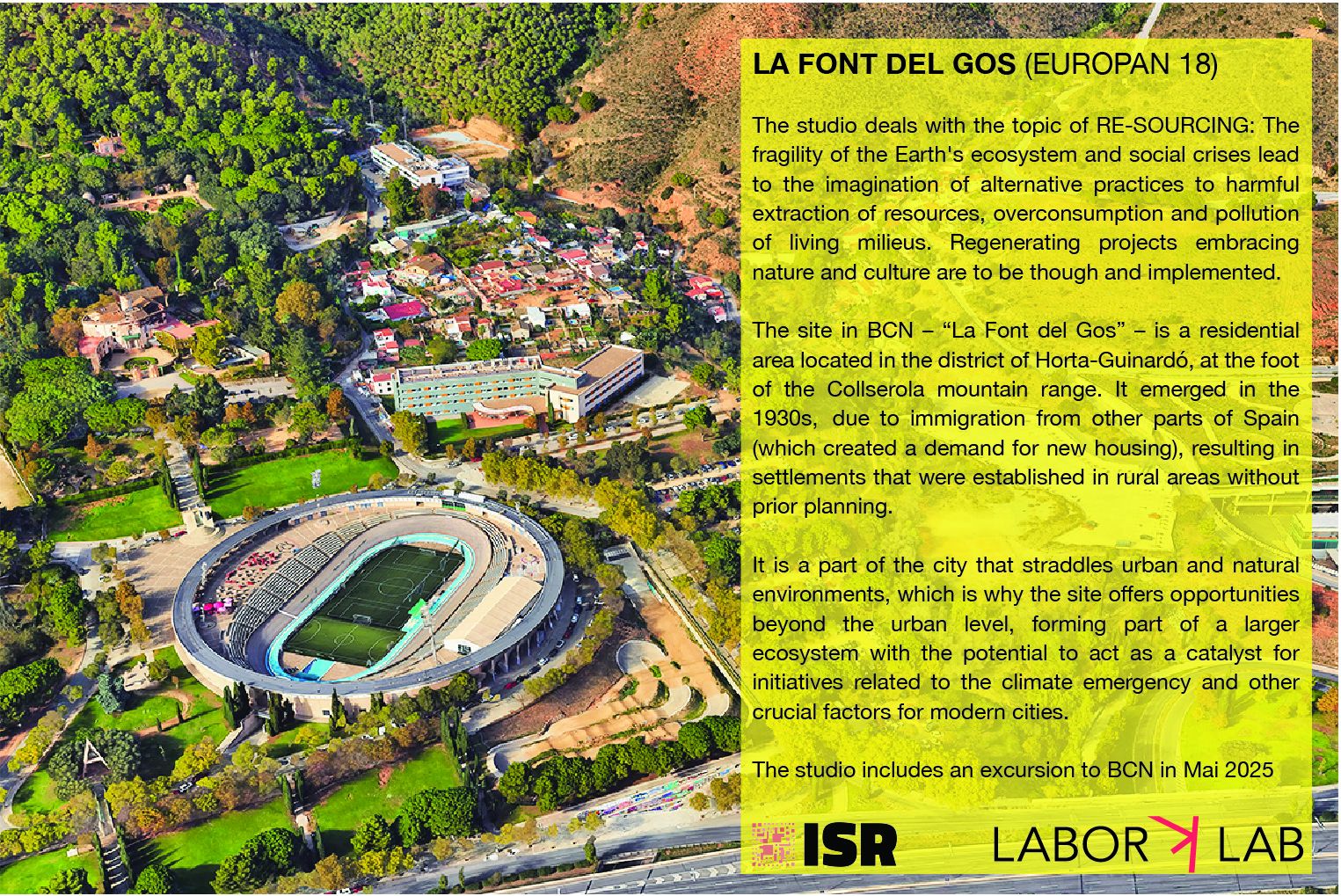
BCN – LA FONT DEL GOS (EUROPAN 18)
Labor K //// K LAB / Dr.-Ing. Andreas Brück
Thursdays 13-16 h | A055 Projectroom "Barcelona"
EUROPAN 18 deals with the topic of RE-SOURCING: The fragility of the Earth‘s ecosystem and social crises lead to the imagination of alternative practices to harmful extraction of resources, overconsumption and pollution of living milieus. Regenerating projects embracing nature and culture are to be though and implemented. It is about weaving synergies between biogeophysical data with socio-spatial justice and health ones. Three main directions for designing forms of resilience and resourcing of inhabited milieus make possible to reactivate other forms of dynamics and narratives around the ecologies of living and caring.
The site in BCN – “La Font del Gos” – is connected to the topic of Re-sourcing from Natural Elements / Regenerating Landscapes. The residential area is located in the district of Horta-Guinardó, in northwest Barcelona and at the foot of the Collserola mountain range. The neighbourhood emerged in the 1930s, due to immigration from other parts of Spain (which created a demand for new housing), resulting in settlements that were established in rural areas without prior planning.
La Font del Gos has never been officially recognized as a neighborhood, a perception influenced by several factors, including the construction of the Ronda de Dalt. This significant road created a physical barrier between the La Font del Gos area and the rest of the city in preparation for the 1992 Olympics. Around the same time and in following years, the construction of other large-scale facilities, such as the Velodrome, furthered the divide between this residential area and the rest of the city. The urban area is located on the typical steep topography. It consists of two main streets that follow the watercourse, forming the two primary settlements: Cal Notari and La Font del Gos.
It is a part of the city that straddles urban and natural environments, which is why the site offers opportunities beyond the urban level, forming part of a larger ecosystem with the potential to act as a catalyst for initiatives related to the climate emergency and other crucial factors for modern cities.
The studio entails an excursion to BCN in Mai/June 2025.
More Info here: https://www.europan-europe.eu/en/session/europan-18/site/barcelona-la-font-del-gos-es
- Trainer/in: Andreas Brück
- Trainer/in: Georg Müller

COMMUNICATION & ADVANCED SPATIAL ANALYSIS (CASA) deals with new analysis and support tools that are needed to guide policy, planning, and design in urban environments that face large climate impacts, differences in impacts across social groups, and uncertainty in decision-making processes for more sustainable urban development and adaptation/transformation.
VISUALIZATION in Urban & Regional Planning: Today & Tomorrow Advanced methods for recording and processing (spatial) data to depict current conditions (incl. data analysis, cartography, and GIS) as well as methods of future exploration and scenario techniques (incl. computer-aided modeling and representation - e.g. 3D rendering, BIM, VR)
COMMUNICATION in Urban & Regional Planning: Interaction & Change Course with a focus on communicative methods of SRP (dialogue, participation, other formats) and the role of dialogue, discourse, and exchange in transformation.
The VIS & COM courses are always held in English (or bilingual DE/EN) to serve the dual-degree Master's "Urban Design" and "Urban Mobility" and to enable other international students (e.g., Erasmus) to participate.
- Trainer/in: Andreas Brück
- Trainer/in: Julia Anna Kowalska
- Trainer/in: Georg Müller
- Trainer/in: Felipe Andres Vergara Ovando
- Trainer/in ohne Editorrecht: Sophia Lina Zwietasch
„Stadt- und Regionalplanung? Raumplanung? Das kann man studieren?“ Diese Fragen kennen wahrscheinlich viele von uns. Die einfache Antwort: „Ja! Es gibt sogar vielfältige und vielseitige Berufswege“ Die Bandbreite und der Berufsalltag sind Gegenstand des Berufspraxisseminars.
Im Berufspraxisseminar wird als Pflichtbestandteil des Moduls BERUFSPRAXIS ein breiter Überblick über die verschiedenen Berufspraxisfelder und Arbeitsalltage in der Stadt- und Regionalplanung und ein Einblick in die Praxiswelt gegeben. Die Bandbreite der Berufspraxis wird mittels thematischer Fachvorträge – den ISR Sommergesprächen – durch Externe (aus öffentlicher Verwaltung, privaten Unternehmen und Büros, Verbänden und Institutionen) vorgestellt. Anhand skizzierter Projekte und Themen zum Stand von standplanerischer Praxis und Forschung werden mögliche Arbeitsfelder erörtert und Berufsbiografien und -wege diskutiert.
Wir starten am 13. Mai 2025 (jeweils 17Uhr) ...Ort und Termine werden noch bekannt gegeben.
- Trainer/in: Andreas Brück
- Trainer/in: Julia Anna Kowalska
- Trainer/in: Georg Müller
- Trainer/in ohne Editorrecht: Sophia Lina Zwietasch
- Trainer/in: Tanja Beier
- Trainer/in: Andreas Brück
- Trainer/in: Gesa Henning
- Trainer/in: Polyxeni Kokoula
- Trainer/in: Julia Anna Kowalska
- Trainer/in: Nija-Maria Linke
- Trainer/in: Angela Million
- Trainer/in: Georg Müller
- Trainer/in: Sarina Schmidt
- Trainer/in ohne Editorrecht: Tion Kudlek
- Trainer/in ohne Editorrecht: Tion Kudlek
- Trainer/in ohne Editorrecht: Christy Rebecca Kulz
- Trainer/in ohne Editorrecht: Anna Neuhaus